The way of life has changed dramatically over the last couple of weeks. COVID-19 really started to get serious here in Blaine County, Idaho when the Sun Valley Company decided to close the ski area and the schools closed down on March 16th, 2020. The county had one confirmed patient (March 14th) that we knew of, as we didn’t have much testing going on at that point.
Last week, I went to the grocery store, which became my new everyday hazard. Before that time, my biggest risks were going out to work in avalanche terrain. I joked with my wife that I was forecasting the hazard to be MODERATE with the problem, being COVID-19. My world was being flipped upside down and I needed to make sense of it. So I looked to the only thing that stays consistent in my winter life… going through the process of creating an Operational Hazard and Risk Forecast. At the time, the only thing being talked about was social distancing (keeping 6’ spacing from those who don’t live in the same household). Therefore, it was possible to trigger a slide (contract COVID-19), but unlikely for it to naturally take you out, and the problem could be found in areas of high traffic (heightened awareness on specific terrain features).
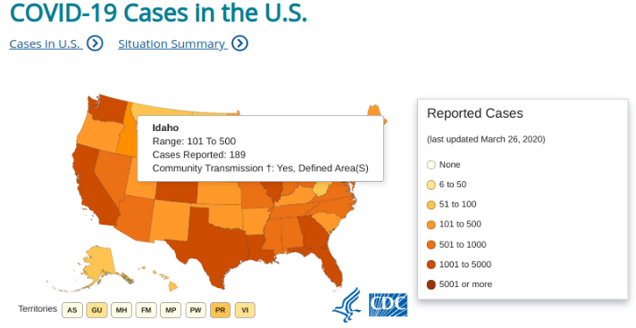
Our national avalanche center (Avalanche.org) has been replaced with a daily viewing of the Centers for Disease Control and Prevention (CDC) Coronavirus: COVID-19 page. The local “avalanche” bulletin depends on what state you reside in… for us here in Idaho, we can navigate to the State of Idaho’s webpage designed to provide information about the novel coronavirus (COVID-19). The “forecasts” aren’t as sexy as the usual avalanche bulletins that we are used to reading each morning. Instead, they consist of daily briefings of new orders that residents need to follow in order to lower the likelihood of spreading the virus across the state.
On March 20th, Blaine County was issued our first “avalanche warning,” which was an ORDER TO SELF-ISOLATE. The storm was beginning to build in intensity, there were growing accounts of human triggering in the county and natural activity would most likely be occurring out there, without us even taking notice. Throwing hand charges was the initial way to manage the problem, but without abundant testing, there were limited to no results. We were ordered to stay in our homes and only leave for Essential Services/Activities. We had to learn what things were Essential to our daily lives.
Are we in a Deep Slab instability right now, low likelihood of trigger, but large consequence if you find that sweet spot. It’s a little hard to compare the release of an avalanche to the spread of a virus. In the scale of time, a virus moves more like the creep in the snowpack than the collapse and release of a weak layer. When this problem is approached with the Strategic Mindset, we are all Stepping Back as more and more evidence is showing community spread. Unessential businesses are closing their doors and we’re closing off terrain where our margins of safety are unnecessarily being compromised. It is fearful that one day it will come to being Entrenched in a well established problem that requires even stricter management practices of a full lockdown scenario.
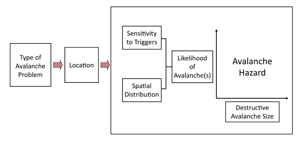
So how do we gauge the trend and severity that we are currently faced? As I was compiling this information, I came across the CDC Pandemic Severity Assessment Framework (PSAF). That’s right, there is already a way to assess this hazard. But I thought it would bring some excitement to my everyday life of isolation to relate this whole pandemic to the avalanche world. I attempted to create some new language on how to analyze this problem with the help of the Conceptual Model of Avalanche Hazard.
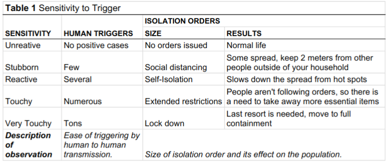
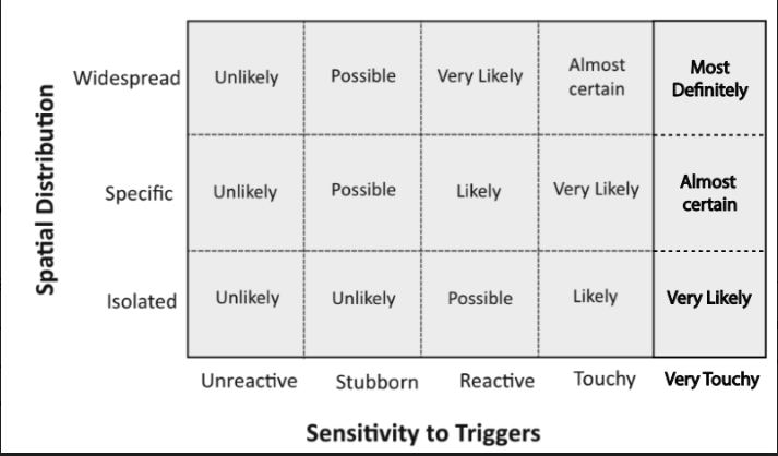
Redesigning the Sensitivity to Trigger table presented the most challenges. I couldn’t come up with a comparison to “natural releases or cornice triggers.” Being that the COVID-19 virus is transferred via humans, it seems unlikely for there to be a natural trigger, besides the initial transmission by a bat? Human triggers seemed to be the most likely way of transfering the virus. I replaced the “Explosive Triggers” with Isolation Orders. Previously this field started out with the largest explosives used to attempt to trigger avalanches that were more stubborn, but in this situation it seems necessary to reverse that process. Instead, I changed the field to act as the amount of restrictions needed to combat the spread of the virus. I brought back the Very Touchy sensitivity, but used it as an additional level of severity (ballsy… I know…).
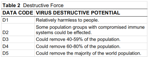
I choose to scrap much of the descriptors of the Destructive Forces as they related to structural damages and didn’t correlate well to the loss of human life. It was difficult to come up with parameters from level to level, but this was the initial attempt. I look forward to constructive criticism.
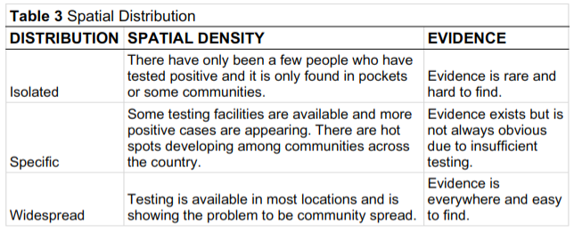
Much of the Spatial Distribution correlates to how much testing is available out there. It was quickly realized that the virus was/is probably present in more areas then we know of, but without sufficient testing, the results are widely unknown. Therefore it only appears to not be present in some communities, even though it probably is occurring there. There just aren’t tests available in those areas yet to prove there are positive cases present.
Based on the parameters listed above, let’s create a forecast for today’s advisory in Blaine County. Our avalanche problem is COVID-19 for in Blaine County, Idaho. The county has 114 confirmed cases (as of March 28th) and is in Extended Restrictions ordered by Governor Brad Little, making the sensitivity at Touchy. St. Lukes has a drive-thru testing site and is performing tests on a daily basis. At this point, Blaine County is known to be at community spread, therefore Widespread spatial distribution. It is Almost Certain to contract the COVID-19 by leaving your house and going to high use areas (avalanche terrain) and not practicing safe travel protocols such as wearing a N95 mask, wearing gloves (and knowing how to not cross contaminate them), keeping a distance of 6’ from others, and of course, washing your hands with soap for at least 20 seconds.
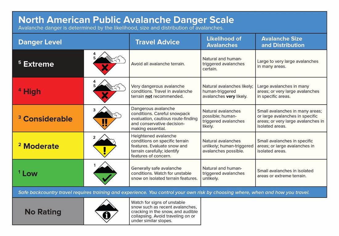
An avalanche center might deem it CONSIDERABLE for those traveling in the forecast area (Blaine County). You might be thinking, “but why isn’t it HIGH today?! It’s scary out there!” Based on the reaction of our government, we’re not in a complete Lock down situation that would require us to avoid all infected areas, such as grocery stores, airports, gas stations, etc. (avalanche terrain). I would argue that conditions as of now, require careful evaluation, cautious route finding, conservative decision making. If you need to leave your house, take precautions to lower your likelihood of acquiring COVID-19. Use cautious route finding at the grocery store, avoid crowded aisles where you can’t adhere to the 6’ spacing of social distancing. When you encounter another individual, space out to limit your chances of “triggering” the virus. With the health system in our community being stressed, now is the time to make more conservative decisions in the backcountry.
I would like to open up this discussion with fellow colleagues. This is a working document and look forward to adding adjustments to the terminology and language of how to manage this new hazard in the unforeseen future.
References:
Statham, Grant, et al. “A Conceptual Model of Avalanche Hazard.” Natural Hazards, vol. 90, no. 2, Feb. 2017, pp. 663–691., doi:10.1007/s11069-017-3070-5.
Atkins, Roger. "Ying, Yang, and You." International Snow Science Workshop, Banff, 2014, https://arc.lib.montana.edu/snow-science/objects/ISSW14_paper_O9.02.pdf.
IdahoCOVID19. “Welcome.” Novel Coronavirus (COVID-19), State of Idaho, 28 Mar. 2020, coronavirus.idaho.gov/.
 RSS Feed
